What are inversions?
In the troposphere, the lowest layer of the atmosphere that reaches the earth’s surface, temperature typically declines with altitude. This rough estimation of temperature with height doesn’t always fit the situation due to weather, terrain, and solar radiation. Anomalies in the the lowest layer of the atmosphere occur when temperatures increase with height due to these factors. These anomalies are called inversions.
When cooler, higher density air, is in place under warm, less dense air the atmosphere can behave much differently than expected. These differences include poor air dispersion, light winds, and fog
Forward to: using the the Mesonet to detect inversions
How do surface inversions develop?
Due to solar radiation, inversions often occur at night at the surface of the earth. These inversions develop through the following process:
- During the day with full sun, the surface heats up due to incoming shortwave radiation. Through convection/conduction, the surface warms the air immediately above that surface. Depending on the terrain cover and exposure (trees, crops, pavement, slope, elevation, etc) these can heat up faster/slower than neighboring terrain. As the solar radiation increases through the day, the surface warms more and mixing increases (as seen in Figure 1).
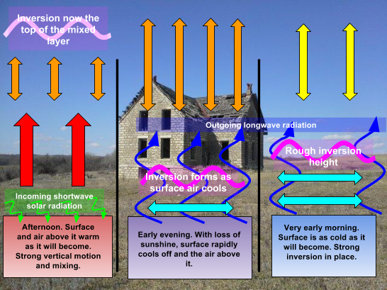
- Once the surface air warms more than the air above it, it begins to rise. Warm air is less dense than cold air and will rise/cool until it reaches equilibrium with the surrounding air. Air will continually rise through the day as long as the surface continues to warm air above it and that air remains less dense than the surrounding air. The height to which this air can rise until it reaches equilibrium with the atmosphere is called the mixing height. Within this mixed layer, vertical motions are present and disperse particles very well. During this period, the surface is the warmest with cooler air above, a typical scenario of the troposphere (right frame in Figure 1, left frame in Figure 2).
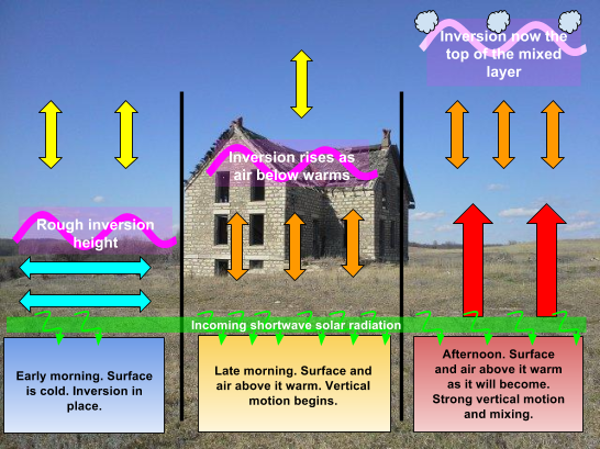
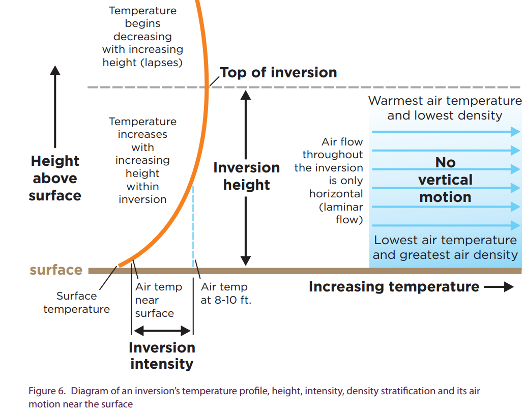
- As the sun sets, incoming solar radiation is lessened and the surface of the earth begins to lose heat through longwave radiation. As this heat is lost, the surface cools. Coinciding with the cooling, it also cools the air just above it as well. This cooler air is more dense and won’t rise, suppressing vertical motion (middle frame, Figure 2). Meanwhile, with increased altitude above the ground, the air will cool at a much slower rate. This develops a stratified, stable atmosphere with warmer, less dense air atop the cooler air - an inversion. Note in Figure 3, an inversion doesn’t have a sharp cut off between cold/warm air but is typically a gradual transition with height. Often, these inversions will continue until the sun rises again the next day (left frame in Figure 1).
Keep in mind, this is an idealized situation. Typically there are many other factors at play besides sun. Some other factors that need considered consist of: clouds, winds, and time of the year.
What factors need consideration?
Inversions are most typical at night as previously described. However, they can also develop during particular weather and are sometimes more impactful based upon conditions, seasons, and time of day.
Clouds
- The presence of morning clouds will prevent initial incoming shortwave radiation reaching the ground. This will often allow for overnight inversions to persist later into the morning than a typical clear morning sky.
- Daytime clouds will continue blocking incoming solar radiation and diminish subsequent surface warming. This allows the surface and air above it to remain cooler. Cooler surface air will inhibit mixing and vertical motion/mixing in the atmosphere. Lack of mixing will prevent good dispersion of particles and promote stability similar to an inversion. Solar radiation can and will still reach the surface despite clouds. However, the amount of mixing will be much more limited than during a sunny day. Also, when the ground emits longwave radiation and cools at night, the air above it is still cool. This will often offset inversion development until later in the night.
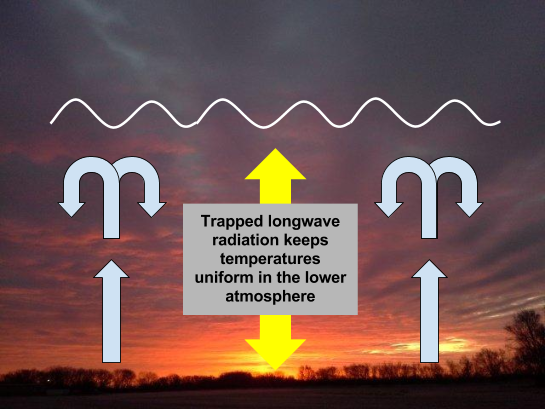
- Overnight clouds will act as a lid and prevent longwave radiation emitted by the ground from escaping the troposphere. This radiation will become trapped near the surface and continue warming the air above. Therefore, inversion development may not occur and/or be offset later into the evening/night.
Winds
- Moderate to strong winds will often mitigate and/or dissipate an existing inversion. Winds typically mix the atmosphere so the cooler dense layer at the surface is forced to interact/rise into the warmer air above it.
- Light winds are usually present with inversions. Lack of winds allows the segregation of the cold/warm air and enhances development of an inversion. Even during calm periods, light winds still exist either due to a regional or local influences.
- Cold air will always sink. As air above the ground cools on hillsides, it will sink into the valleys and lower terrain. This develops weak to moderate local winds that will enhance/strengthen inversions in the low areas.
- Wind breaks, tall crops, and sheltered regions will mitigate wind flows in a local area. This will more effectively trap cool air and develop inversions quicker after loss of solar input in the evening. Shadows will also create inversions earlier in the afternoon and take longer to dissipate in the morning.
Moisture
- Humidity has a substantial influence on the capacity of air to warm/cool and is the most important greenhouse gas. Presence of abundant moisture/water vapor will act as an insulator and cap the longwave radiation near the surface similar to clouds.
- Dry air will warm rapidly and allow for quick dispersion of an inversion in the morning. However, it will also allow air to cool faster with more rapid inversion development earlier/faster in the evening. This also enhances inversions at night and can develop some of the strongest inversions.
- Presence of moisture in a high humidity environment will slow inversion development. However, an inversion is usually more obvious with the resulting presence of fog and/or dew in the morning.
What are inversion impacts?
Inversions have a substantial impact on the dispersion of particles as well as surface temperature. This has a resulting influence on smoke, spraying, and weather forecasting.
Smoke
- During prescribed fire season in the Flint Hills, smoke dispersion is critical to air quality in the surrounding region. An inversion in place will prevent smoke from rising high into the atmosphere. This will trap it near the ground and increase the duration it will sit over the area of the fire and diminish air quality.
- Light winds associated with an inversion will allow the smoke to move as a large mass and be transported easily the next day. This will create smoke problems downwind in the next 12-24 hours once the inversion disperses.
Spraying
- Presence of an inversion will effectively trap the fine droplets (mist) off a sprayer near the ground. This will allow the concentrate to remain airborne and not fall completely to the surface/crop. Coarse drops will still effectively reach the surface.
- Very light winds will gradually move airborne concentrate horizontally into nearby areas.
- Local influences on wind are extremely likely and will dictate the direction that any suspended spray will drift.
Frost/Freeze
- Strong cooling at the surface through longwave radiation can allow temperatures to drop below freezing. This can be particularly concerning during the growing season.
- When warm air is present above the freezing temperatures during an inversion, agriculture can utilize fans to force mixing. By pushing the cold, denser air upwards, it in turn forces warmer, less dense, air downward. This will effectively raise the temperature and prevent cold air damage to surface vegetation.
Using the mesonet to determine presence of an inversion.
In 2017, Kansas Mesonet has began an update to add the ability to detect the presence of inversions. This is done by adding a second temperature sensor at another height above the ground. We have done this at all our tower stations and added it at 10m (30 feet) above the ground. The difference between the 2m (6 feet) and 10m (30 feet) sensors will indicate the presence of an inversion as well as low level stability. Keep in mind, inversions often differ greatly over very small distances. These observations provide a small snapshot of regional conditions but aren’t necessarily representative at your location. When viewing the inversion data here: mesonet.ksu.edu/agriculture/inversion the following dataimplies:
- Positive values infer that temperatures are warming with height and a surface inversion is in place. The more positive the value, the stronger the inversion at the surface. Values 10F and higher are considered a very strong inversion. Oklahoma Mesonet has recorded inversions up to 20F, a very rare phenomenon that implies a significant inversion (Hunt et al., 2007).
- Negative values indicate the temperature cools with height and is unstable. Therefore, no inversion is in place and mixing is effectively occurring. The more negative the value, the more cooling with height exists and the faster air parcels will rise.
- Zero values represent temperatures at 2m and 10m are the same. This indicates either stability or instability at the surface dependent upon the time of day.
- In the morning: zero values indicate the inversion developed vertically to heights higher than 10m.
- In the afternoon: strong mixing of the layer has equalized the temperatures between the two levels and the atmosphere is unstable.
- In the evening: atmosphere is likely stabilizing and an inversion may soon develop.
- Winds at 2m are critical when an inversion is in place. They will vary and be mainly light and terrain influenced. However, this will indicate the direction that spray, etc will drift when it remains near the surface. The wind barb (represented by a ---- protruding outward from the value at a specific location) will indicate the direction the wind is coming from (direction wind would blow in your face if you were turned that way). Flags on the end of the wind barb indicate speed. A short flag = 5mph, long = 10mph and a triangle = 50mph. Add up all the flags on a wind barb to obtain the total wind speed.
How can you tell in the field if an inversion is present?
More times than not, there is no simple way to determine the presence of an inversion. You absolutely must take temperature measurements at two different heights to determine the change in temperature with height.
Occasionally, there are some visual indicators of an inversion. A few of these are:
- Low lying fog in valleys, low points, and over different ground cover.
- Poor dispersion from chimneys, industry, and dusty roads.
- Frost/dew on the ground.
- Sounds travel large distances.
References
Enz, J. W.; Hofman, V., and Thostenson, A. 2014. Air Temperature Inversions: Causes, Characteristics and Potential Effects on Pesticide Spray Drift. AE-1705. NDSU Extension Service publication.
Hunt, E. D., J. B. Basara, and C. R. Morgan, 2007: Significant inversions and rapid in situ cooling at a well-sited Oklahoma mesonet station. J. Appl. Meteor. Climatol., 46, 353–367, doi:10.1175/JAM2467.1.